Gravity Case Study:
I was contracted by Kennecott Minerals Greens Creek Mine to collect gravity data on four survey grids to explore for massive sulfide deposits. The Greens Creek Mine is a polymetallic massive sulfide deposit located on Admiralty Island near Juneau, Alaska. The mine has an exploration program to look for additional deposits on the island. Since the density of massive sulfides is approximately 4.1 g/cm3 and the average crustal density of the earth is only 2.67 g/cm3, gravity can be a very effective exploration method.
The gravity method is used to measure density contrasts in the earth. Readings are measured in units called Gals named in honor of Galileo. A good accuracy for a production survey is to measure changes in earth's gravitational field to 0.1 mGals. For comparison, the earth's field has a magnitude of 980,000 mGals. To make matters more difficult, the gravity field is also affected by instrument drift, ocean tides, latitude of the earth, elevation, and terrain. To make accurate estimates of the gravity field caused by density contrasts, the operator must accurately know his horizontal position within 30 feet, vertical position within one inch, instrument drift and tidal cycles, and terrain. Good position location is routinely obtained using either a differential global positioning system (GPS) unit or conventional surveying. Good estimates of instrument and tidal drift are made by periodically repeating station observations. The accuracy of terrain corrections depends upon the steepness of the terrain and the accuracy of knowledge of the terrain. In generally flat areas terrain corrections may not even be needed. In very steep areas, notes of topography near survey stations are made in a field book and extensive corrections are calculated using computer programs and digitized elevation data. Changes in elevation near survey stations have a much larger affect on data reduction than changes in elevation far away. Once all of the corrections are made, the geophysicist can interpret the data and model any anomalies of significance.
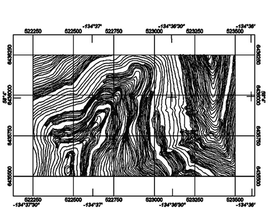
The surveys at Greens Creek were designed to locate massive sulfide deposits. Stations were located 100 feet apart and lines were 400 feet apart. For a massive sulfide deposit to be large enough to be economic, it would have to be long enough to cross two lines and be present on multiple stations on each line. Lines were brushed and picketed at approximately 100 feet intervals by line cutters prior to my arrival. A survey crew followed behind me to survey in the position and exact elevation of each picket. Survey conditions were difficult. Southeastern Alaska is characterized by very steep topography and abundant rainfall. Figure 1 shows a contour map of the Upper Big Sore survey grid. The trees regularly grow to heights greater than 100 feet. Deadfall from these trees littered the ground forming a thick carpet of spongy humus and occasional tree trunks that were thicker than a man is tall. These conditions slowed down data acquisition considerably. I made estimates of local topography at each survey station using an inclinometer. An inclinometer is a small handheld instrument that measures the slope. I took readings perpendicular to the survey lines and in cases of very irregular topography noted breaks in slope perpendicular to and along the survey lines. These readings were made to increase the accuracy of the terrain corrections.
Figure 1: Contoured elevation map of the Upper Big Sore Grid. Smallest contour interval is 10 feet.
I did all data processing at night during the survey except for terrain corrections. Terrain corrections were much harder to complete. The Greens Creek Mine had previously contracted an airborne survey to improve the accuracy of the topographic data available for the area around the mine. Standard procedure with airborne topography surveys is to fly a regular pattern over the area of interest while bouncing a laser beam to the ground. The travel time of the laser beam is measured and the distance to the ground can be calculated if the altitude of the airplane is known. In cases of tree cover the topographic maps created are not as accurate because sometimes the laser beam gets bounced back by the forest canopy instead of the ground. In the case of Admiralty Island where the trees are very tall, these errors were very large. I compared the elevations calculated from the airborne survey with the surveyed station elevations and found they regularly differed by 20 to 30 feet. For comparison, an error in elevation of 10 feet can produce an error in the gravity value as large as 0.6 mGals. It was clear the existing topographic information would be insufficient for doing terrain corrections. Therefore I hand contoured the terrain to honor the station elevation values and digitized these contours (see Figure 1). These digitized values were then used to replace the airborne survey elevations near the survey grids. This greatly reduced errors in the processing.
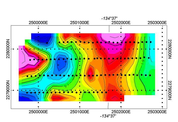
Figure 2: Complete Bouguer gravity values for Upper Big Sore grid. Contour interval is 0.1 mGals.
The final processed gravity data for the Upper Big Sore grid is shown in Figure 2. This grid is located to the south of the mining operations at Greens Creek. The Greens Creek Mine operations are extending to the south following the ore zone. The Upper Big Sore grid was designed to track the ore zone to the south. The gravity high on the extreme western edge of the grid is probably caused by lack of good topographic control at the edges of the survey area. Note the gravity high that runs from the north to the south through the grid. This gravity high corresponds with the known information on the southern extension of the ore body. Using a modeling program, I modeled the gravity high using a massive sulfide body (Figure 3). The top panel shows a plan view of the ore body (orange). The middle panel shows the observed field data (green dots), the model curve for ore body (black line), and the difference between the model and observed data (red line). The bottom panel shows a cross section of the ore zone under the mountain. The position and depth of this modeled ore body agree with the known extension of the mined ore body. Note the modeled depth occurs between 300 and 400 feet below the surface. That is about the depth limit for being able to reliably detect a massive sulfide body using gravity.
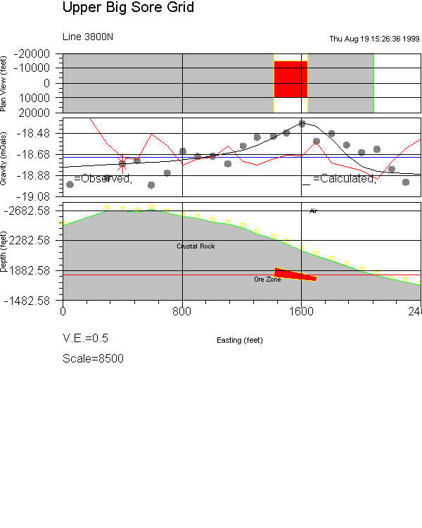
Figure 3: Model Ore Zone for Line 3800N, Upper Big Sore grid.
Compare the Upper Big Sore grid data to the Bruin grid located in similarly steep terrain (Figure 4). The Bruin grid is characterized by a gravity gradient to the northwest but no distinct gravity highs are present. The few isolated highs in the data only occur at a few data points and are probably caused by errors in the topographic data rather than density contrasts. By comparing these two grids, we can conclusively say there are no massive sulfide deposits in the Bruin grid located within 400 feet of the surface large enough to be economically viable. While the cost of the gravity survey was high, it provided Greens Creek with valuable information to guide their future drilling programs which are much more expensive than geophysical surveys.

Figure 4: Complete Bouguer gravity values for the Bruin grid. Contour interval is 0.1 mGals.
Gravity surveys always require special care because the effects measured are very small compared to the earth's gravitational field. This case study shows how good quality data can even be collected under difficult conditions.
Results presented with permission of Greens Creek Mine.